- Home
- >
- Preservation Archaeology Blog
- >
- Documenting Painted Rock Petroglyph Site
Fran Maiuri, Archaeology Southwest member and volunteer
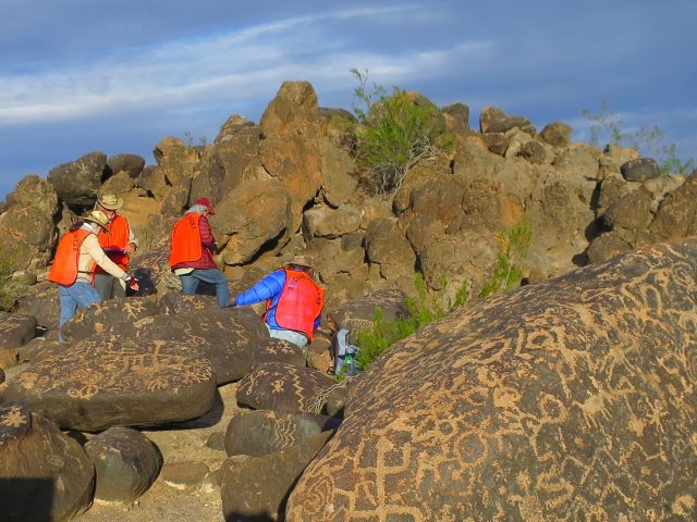
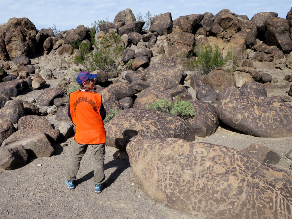
(February 14, 2017)—We’re in the middle of over 500 boulders with petroglyphs on them and we’re wearing bright orange vests that say ARCHAEOLOGIST. Five of us—Kirk Astroth, Carl Evertsbusch, Jaye Smith, and Lance Trask—are volunteering for Archaeologist Southwest, recording the Painted Rock Petroglyph site. This site is managed by the BLM, and it is part of the proposed Great Bend of the Gila National Monument. Surprisingly, even though it is a public site with a formal trail and interpretive signs, the site has never been formally recorded. We’re here to help Aaron Wright do that.
The project begins with the Rock Art Stability Index (RASI), shared with us by Niccole Villa Cerveny, one of the developers of the index. We attend a half-day training and wonder how will we ever remember all the new terms—lithobiont, fissure independent of lithification, efflorescence vs. subflorescence. With the other volunteers we joke about all this new language, but we go home and read through the online references, and study. When we arrive on site for the two-night campout and three days of work, we are unsure of our skills. Niccole leads us through sample boulders and we’re on our way. The process becomes familiar and we sail through the analyses until we run out of forms. It turns out Aaron has underestimated how much work a small group of volunteers can complete in two and a half days! As our schedules allow, we come back for two days each of the next two weeks and finish the nearly 600 boulders.

Now, it is time to photograph. We learn a whole new process for photograpy. We will photograph for three-dimensional representation with direction from Archaeology Southwest’s Doug Gann. Each boulder needs from 60 to more than 100 photos from all angles and directions so that Doug has enough to stitch together to make a 3D representation of each! We’re game, and the work continues. We are using auto windshield reflectors for shade and a small, high-quality point-and-shoot camera.
The first couple of days are slow. The shade is clearly not large enough for the super boulders on this site. The photography involves bending, holding the camera still, and keeping an 18-inch distance from the boulder, while stepping around boulders nearby. As the photographer, I’m glad I do boot camp workouts three days a week! My body is in many different configurations those two days.
In a day and a half we complete 43 boulders. Can we sustain this? We have more than 550 more to photograph! During the week, Doug runs some of our photos to create the 3D example. The surface of this boulder with the pecking looks awesome. On our cell phones and computers we can navigate around the rock, look at all sides, and turn it around. Unfortunately, there are holes in two sides of the rock. We did not have enough good photos to stitch a complete 3D representation. We go back to the drawing board.
After problem-solving by email and with consultation from Doug, the team shows up the next week, with a new shade contraption, selfie sticks, a Go-Pro camera and the original point-and-shoot camera. Two photographers and a two-person shading team work for two more days, and now we have nearly 200 boulders photographed. Now we’re waiting to see how it all works out. If the Go-Pro works, it is a much faster and easier-to-use option. We’ll know more soon, but the mystery of archaeology and new methods of data collection are part of what keeps us coming back! (Check out Doug’s post on this here.)
Archaeology Southwest’s work at Painted Rock continues. If you visit the site, and you see some folks among the boulders wearing orange vests, don’t be fooled. We’re not all trained Archaeologists. Most of us are volunteers, being challenged, sharing our skills, and enjoying our time in these special sites we are working hard to document and preserve!

6 thoughts on “Documenting Painted Rock Petroglyph Site”
Comments are closed.
Explore the News
Related to This
-
Location Painted Rock Petroglyph Site
Fran – great article. You guys seem to be having so much fun and I love that it is getting shared widely on Facebook. Maybe I should have joined you afterall.
In 1968, the late Paul H. Ezell, Ph.D., loaned four students $40 to drive from San Diego, CA, to Tucson, AZ to attend the Gran Quivira Conference at the Santa Rita Hotel. As he handed us each $40, he asked that we take the time to stop at Painted Rocks Reservoir and examine the petroglyphs. The late Harvey Shields, Dan Sheedy, Dave Kinder and I made that stop and marveled at the high concentration of rock art. We shot a few photos and then wandered off to get lost in a cat’s claw bramble, shoot some scenery, then found the car and drove on to other adventures. But when we returned to San Diego and showed the photos to Ezell, he got excited because we documented a long “lost” Jesuit trail that he had been searching for on many expeditions. That diversion meant we never officially returned to Painted Rocks. The next trip out in 1973, I observed a formal campground that really detracted from the natural setting of this fantastic site. But I am amazed that no one formally recorded the site, especially since it was part of the famous Painted Rocks Survey back in the 1950s.
Do you need more volunteer help? I am jobless and have semi pro camera, will travel from Tucson.
What you have accomplished is very impressive and much needed. Is the survey completed at this time? If not, or if any further assistance is needed please contact me. I was initiated into the rock art recording field school via ASNM at 3-Rivers Petroglyph Site, New Mexico, in 1991. The course led me to great recordings in the Galisteo Basin, Rio Grande Gorge, Mesa Prieta Petroglyph Project, and to date the Petrified Forest National Park. I am a professional illustrator and good photographer. My application to assist in any future help comes with multiple references and an eagerness to volunteer my talents. Keep up the GREAT work!!!
Archaeological Field Illustrator looking for rock art projects
In response to Ron May above, that’s a fascinating personal connection to Paul Ezell, and Painted Rocks. Thanks for sharing. Just to clarify, the Painted Rocks Petroglyph Site was “recorded” first by Frank Midvale for the Gila Pueblo Foundation in 1929, under the site designation E:16:1(GP). In 1952, Al Schroeder recorded the site as S:16:1(BC) as part of his National Park Service survey for the Davis Dam. Then, in 1959, William Wasley recorded the site as AZ S:16:1(ASM) as part of the Painted Rock Reservoir Survey. By “record,” I mean they filled out a site card with some brief (very brief!) information. We’ve never really known anything about the site other than the presence of petroglyphs. How many? How large is the site? What else is there besides petroglyphs? That’s what we’ve recorded at Painted Rocks, and hope to share soon.
I suspect Dr. Ezell was aware of the Painted Rocks Petroglyph Site, though he may not have ever visited it. Ezell conducted a major survey of Organ Pipe Cactus National Monument, south of Painted Rocks, in 1951 and 1952. He also assisted Al Schroeder with the initial Painted Rock Reservoir Survey in 1957. Although that survey didn’t include the Painted Rocks Petroglyph Site (located downstream of the reservoir), it’s reasonable to assume that Ezell was familiar with Schroeder’s prior documentation of the site. The “Jesuit Trail” he referred to was likely that of Jacobo Sedelmayr. Dr. Ezell and his wife Greta transcribed and published one of Sedelmayr’s letters from 1744, about his trip down the Gila River from Tubutama, in Sonora, to the confluence of the Gila and Colorado Rivers, near present-day Yuma. Sedelmayr made that trip several times, and in one of letters from 1748, described his visit to “las piedras escritas,” the Painted Rocks. Although unpublished, Dr. Ezell transcribed this 1748 letter as well, a copy of which is on file with the Arizona Historical Society in Tucson.