- Home
- >
- Preservation Archaeology Blog
- >
- A [Digital] Tonto Basin Journey


(March 15, 2021)—What is a path? Dictionary.com defines path as “a way beaten, formed, or trodden by the feet of person or animals. A narrow walk or way.” That seems a reasonable enough answer, but archaeology shows that the answers may be more nuanced or complex. The route from A to B sometimes includes a C or even a Z. You may use the same route between your home and work, but there are times that you need to modify the route to get gas or pick up dinner. Barring a change in employment or residence, A and B stay the same, but the path becomes increasingly more intricate over time as C, D… ZZ are visited. In archaeological-speak, the path becomes a palimpsest of action.
In this post, we discuss how digital data can be used to identify possible ancient paths and routes.
The Shortest Path Is Not Always the Straightest
In his post “Following in their Footsteps,” Aaron Wright talked about using the locations of artifacts to identify trails that are not visible on the surface. The plotting of each artifact in a GPS unit created a map that revealed a network of Indigenous trails between the Gila River Indian Community and the Colorado River, including the Komatke Trail. This method uses the fragments of the past to show where people traveled.
A major drawback of documenting the location of artifacts to find trails is the cost in time and money. Aaron and his crew of Kwatsáan Tribal members have demonstrated the intrinsic value of the work, of course, but it is helpful and economical to have an idea of where paths might be.
You’ve undoubtedly heard the shortest route between two points is a straight line, or “as the crow flies.” If you have spent any time driving or hiking around Arizona or northern New Mexico, you know that this is not true. To illustrate this point, we drew a straight line between central Phoenix and Tucson using Google Earth.
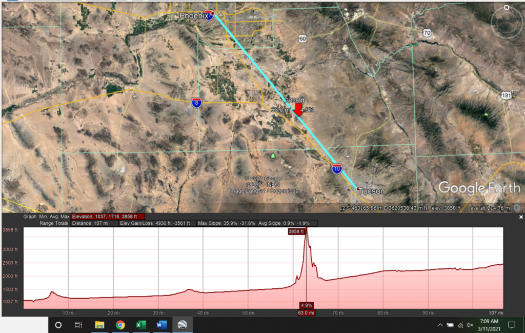
A nifty feature in Google Earth is the ability to see changes in elevation between two or more points. The picture above shows that the Picacho Mountains, marked by the red arrow, would interrupt any leisurely stroll between the cities. To make the journey reasonable, a different path is needed.
Freeways through mountainous areas provide a good example of how engineers deal with the straight-line problem. If you have driven between Phoenix and Flagstaff, you will have noticed the road is steeper going north than south. The picture below shows the north and south bound lanes of the I-17, south of Sunset Point Rest Area.
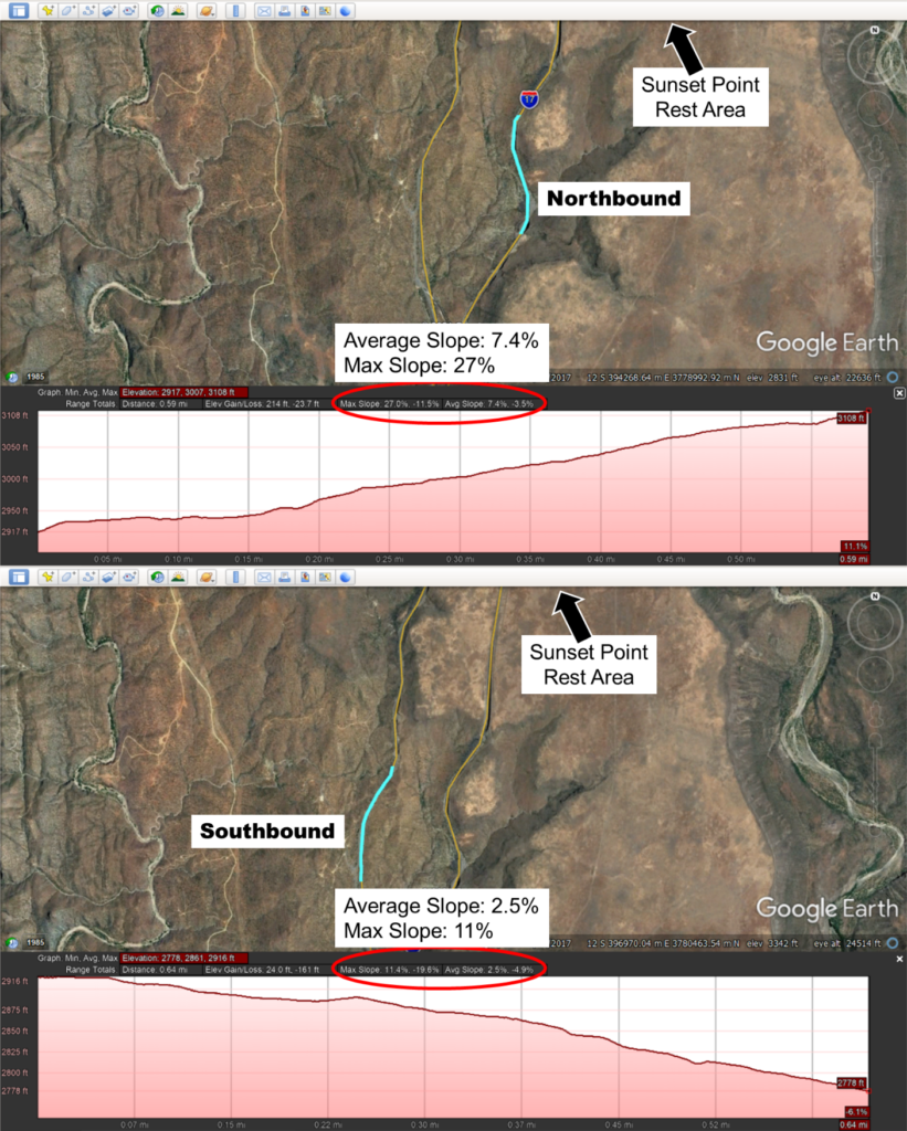
As you can see, the northbound lanes leading to the top of the mesa are much steeper than the southbound lanes. The two lanes are running between the same two points, Phoenix and Flagstaff, so why the difference? Speed. Steeper declines increase speed, possibly causing vehicles to lose control and veer off the road. In this case, a gradual decline is less costly than a steep one.
A common assumption applied to foot travel is that the route between two points will follow along the smallest difference in elevation, or slope. Determining this route with Google Earth would take more time than anyone would care to spend. Fortunately, there is an easier way.
The Path of Least Cost
A cost path analysis is a popular way to find possible routes. The analysis determines the least costly path between two points based on one or more variables that describe the resistance, or cost, to move through those landscapes. For example, there is more resistance (pain) walking uphill through Catclaw Acacia than along a flat sidewalk. The simplest way to find the least cost path (LCP) is by creating a slope map.
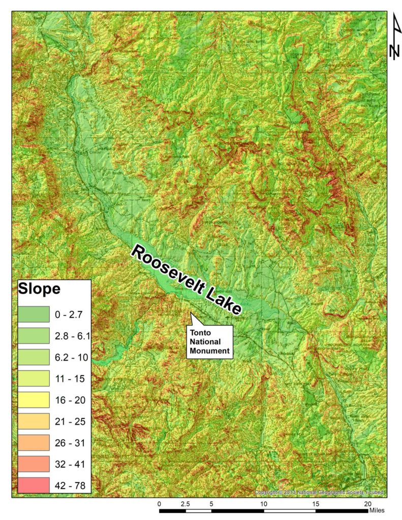
To create a slope map, like the one shown above, we first start with a digital elevation model, or DEM. A DEM is a file that records changes in topography across a landscape. Each data point on the DEM, known as grid cells, represents the average elevation of that area of the ground. The DEMs we use, which are freely available from the US Geological Survey, have cell sizes of 30 x 30 meters. Thanks to orbital satellites, DEMs have been created for the entire world. LiDAR sensors mounted on aircraft or even drones can provide sub-inch elevation readings. Highly precise DEMs over a large area can crash computers, so 30 x 30 meters balances precision with time and computer processing costs—aka frustration.
The slope calculated by comparing the elevation of each grid cell to all its neighbors, resulting in a map that is like a sheet draped over the DEM. Presto! You have a cost surface to calculate the LCP between any two points. How an LCP is calculated may be more detailed than you care to read, so we will move on. A quick internet search for least cost paths can satiate those hungry for the specifics.
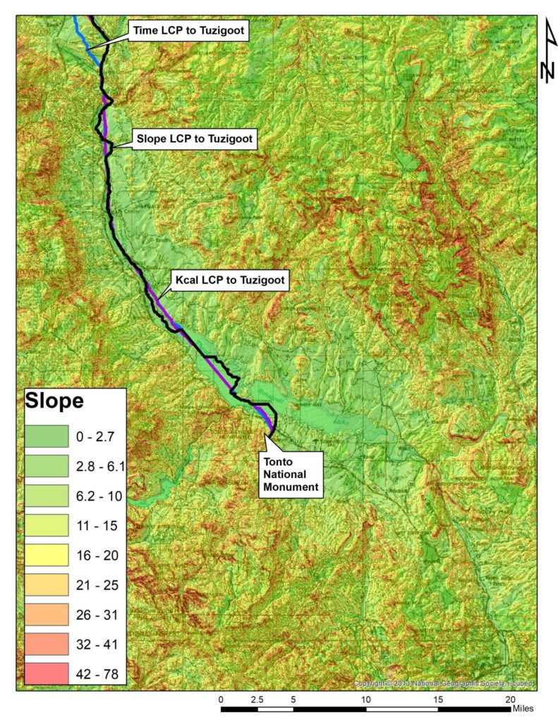
The map below shows a portion of the LCP between Tonto National Monument (TMN) and Tuzigoot, based on slope. In this example, the path follows Tonto Creek to the edge of the map.
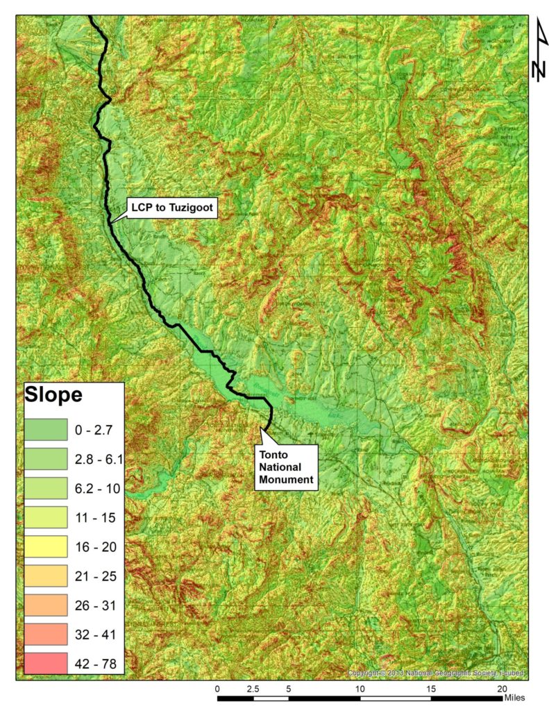
You may say to yourself, “It’s following a stream, I’m not surprised.” It’s a logical thought. Barring a waterfall, the area flanking a stream does not have dramatic changes in slope, as compared to that hill with Catclaw Acacia. That said, the direction and terrain a site sits on will take slope LCPs away from waterways.
We could stop at this point and say this is the route between TNM and Tuzigoot—or, more correctly, go into the field and look for signs of the path. But there are other costs beyond slope that may shape a route.
For a study of trails from TNM to other parts of the Southwest, we created LCPs to minimize the amount of energy or kilocalories someone would expend walking (Kcal) and the amount of time needed to reach the destination, in addition to slope. The results show that despite going to the same location, the three types of paths could be miles from each other and run through very different terrain. The map below shows the three paths from TNM to Tuzigoot. Although they parallel each other through the area shown, they do not completely overlap. Instead, the slope LCP meanders, while the Kcal and time paths take a more direct route.
So, what does path cost tell us about the past?
Digital Paths and Social Connections
Paths are not simply the way people traveled, but often also hold social meaning. Consider Route 66: More than a road between Chicago and Santa Monica, California, it evokes the freedom and possibility of the postwar years. Among the Akimel O’Odham, the Komatke Trail is a part of origin stories. Special places are just as likely to shape a route as a steep incline.
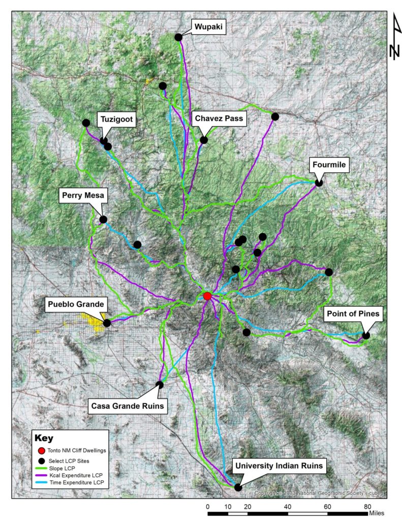
Least cost paths have been used to understand the migration of people from Mesa Verde to the upper Rio Grande and to highlight distant social connections. For us, it provides a starting point. We can now test the validity of the routes by reviewing archaeological records and on-the-ground survey.
Further, it allows us to compare the paths to site locations and artifact assemblages. A site “in the middle of nowhere” with significantly more nonlocal decorated pottery than its neighbors may have been a waypoint along a trail, say between TNM and the Little Colorado River or the Phoenix Basin.
In sum, digital paths can show the routes to social organization and relations in the past.
One thought on “A [Digital] Tonto Basin Journey”
Comments are closed.
Explore the News
-
Join Today
Keep up with the latest discoveries in southwestern archaeology. Join today, and receive Archaeology Southwest Magazine, among other member benefits.
Thanks for the provocative post, Chris and Grant
Neat GIS tool, for sure.
Let’s also remember (1) that what we may refer to as “archaeological sites” are complexes of social, ecological, historical, and political interactions (“places” might be a fairer term) and (2) that travel routes are similarly complex.
With this in mind, I appreciate your note that LCPs are starting points for studies–baselines for assessing complex and dynamic behavior patterns. People may have had all sorts of reasons for not following paths of least resistance: visit friends; tank up at a favorite spring; because they were taught to go a particular way; to avoid dangers real or perceived. Great to leave open paths to considering these reasons, too!