- Home
- >
- Preservation Archaeology Blog
- >
- Recent Field Visits for the Salado Preservation In...
The next phase of the Salado Preservation Initiative began last month, when Bill Doelle, Jeff Clark, myself, and our new Preservation Fellow, Lewis Borck, headed to the field to visit several sites in the Sulphur Springs Valley, on the west side of the Chiricahua Mountains, and some sites in the Upper San Bernardino Valley, on the east side of the mountains. Our intent was to visit sites where we hope to do some limited test excavations, as well as sites for which we will be relying on previously excavated material.
Some of these sites were described by Sauer and Brand in 1930 and by University of Arizona student Louis Caywood in 1933. There was a long hiatus until survey work by Woosley and Price (Amerind Foundation) in the mid-1980s and work by Cochise College’s archaeology program, which was active in the region in the late 1970s through late 1980s. Other than some Gila Pueblo publications and work by the University of Arizona at the Ringo site along Turkey Creek, excavation has been limited to the work of avocational archaeologists Vera and Jack Mills at the Kuykendall site.
Our trip took us first to a large drainage off the Dragoon Mountains, to a site surveyed intensively by Woosley and Price. Our visit confirmed that what they had mapped in 1985 was intact on the ground, and the landowner was thrilled to learn of our interest in putting in a few 1 x 2 meter test pits this spring. Our next stop was Sunsites, where we visited a large, extensively looted adobe room block. Little information exists about this site, and our knowledge of the site came secondhand via Amerind.
Next on the list was a site discovered by Gerald Kelso in 2009, during work in advance of a Natural Resources Conservation Service environmental quality improvement project (in this case, brush clearing). While conducting his survey, he came upon a Salado adobe room block. Kelso then notified us, and Jeff was able to confirm Gerald’s assessment on the ground. We flagged the site boundary, and no brush clearing has occurred within it. Since that time, the landowner has graciously agreed to allow us to visit the site, and has recently agreed that we may map the site using aerial photogrammetry. We will also be able to excavate at least one test pit in a trash mound adjacent to the room block. The site exhibits no obvious looting, which remains a mystery, given the extensive looting that occurred on a site a few hundred meters to the north. Amerind had located and documented the latter site, but did not survey the area of the room block we will be investigating.
We spent the night in Douglas at the historic Gadsen Hotel and we enjoyed a yummy Mexican meal at El Café east of downtown. The morning found us hot on the trail of the Mud Springs Ruin site, another site documented by Sauers and Brand. They noted the presence of two room blocks in the area, and with the aid of site card maps, we found both sites. Located on State Trust Lands, one site was extensively looted (an old screen was still on site), but the other was virtually untouched—go figure! A large cave opening was clearly visible on the ridgeline to the south, begging our return.
Following our Mud Springs visit, we met Peggy Boss, owner of the Boss Ranch and the Boss Ranch site. Partially excavated by John Douglas in partial fulfillment of his master’s degree, it is one of few excavations of sites in the southern Chiricahua Mountain region. Ms. Boss was a gracious host, well remembering Douglas’s excavation. John documented 300 years of human habitation at the site, including significant occurrences of Salado polychrome. The site was much larger than it appears at present; railroad and modern highway construction may have destroyed portions of the site.
We ended the trip on the Grill Ranch. This site was first noted by Charles Di Peso as a minor addendum to a site card prepared for a large cave site in the northern Chiricahuas. He noted a twenty- to thirty-room pueblo and commented, “the presence of another Gila poly site on the east side of the Chiricahuas raises the old question…Why so much Gila Poly, so far south and east?” Why, indeed…? Stay tuned.

4 thoughts on “Recent Field Visits for the Salado Preservation Initiative”
Comments are closed.
As a Cochise County native it is good to see attention given to sites in our area. For too long Cochise County has been a bit of a black hole for archeology.
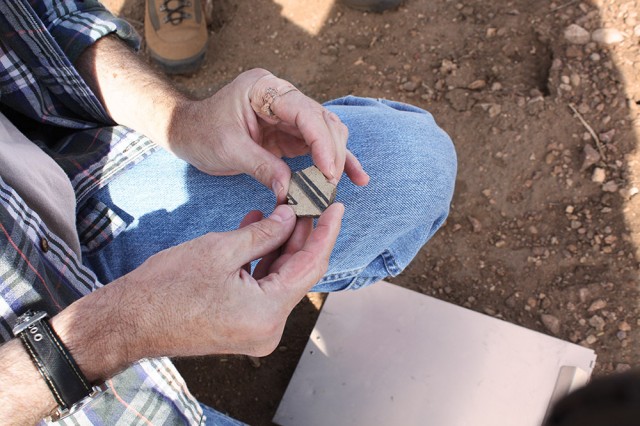
We have documentation written by Jack and Vera Mills about the Webb Site, which sits just a few yards to the west of our property line (we are located on what used to be the town of Webb, just north of Elfrida). The first sherd we found was a black and white piece very similar to the one that Jeff Clark is holding in the above photo. We found that piece in our back yard. Ironically, we were digging up the ground to plant Indian corn! There are sherds all over our 30 acres. We’ve picked up about 3 1/2 coffee cans…and before you have a heart attack, we have documented the locations of our findings. Rick (my better half) has named his part of our enterprise “Salado Farms” in honor of those who were here before us.
Salado Farms! That’s great, Joanne. Thanks for letting us know about the Webb site documentation.
Would love to know what becomes of the test pits if they happen. We found several Salado sites during those surveys, and I have always thought they needed further studying.