- Home
- >
- Preservation Archaeology Blog
- >
- Tucson: Ancient, Historic, and Modern

May 20, 2015—Last Friday morning, as I left for the office, my daughter asked what I wanted for dinner that evening. (She’s learning to write, and wanted to make out a shopping list.) I told her it would depend—on whether or not we had something to celebrate.
That was the day I’d learn whether my proposal to the Southwestern Foundation for Education and Historical Preservation would be funded. I had proposed to develop a 5- to 6-minute animation that would build upon substantial recent research on Tucson’s ancient and historic eras. My goal is to help people—especially elementary-school students—understand where they fit in the rich human history of this unique desert community.
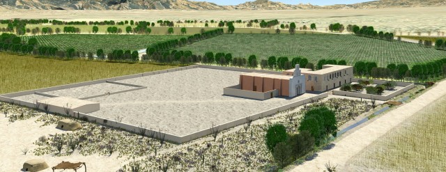
To beget that expanded sense of place, I plan to re-create and update Tucson: Ancient, Historic, and Modern, an original digital animation Archaeology Southwest created in 2003 for the Rio Nuevo redevelopment effort. At that time, the concept involved using three-dimensional (3D) computer graphics first to show modern downtown Tucson, and then to explore how this space related to the historic Tucson Presidio, the San Agustín Mission, and the much earlier Colonial period Hohokam village that once stood at the same place. The animation incorporated archaeological research undertaken for the Rio Nuevo project.
The original Tucson: Ancient, Historic, and Modern video.
The guiding principle behind the interpretive potential of that original video was based upon Kevin Lynch’s classic 1960 study, published as The Image of the City, which explored how people come to know a place by relying upon a mental framework of nodes, paths, edges, districts, and landmarks. Lynch went on to explore how this idea of an internal image of a city could help people better understand the history in the places they had already come to know. One of the key features of Tucson: Ancient, Historic, and Modern is the way landmarks, edges, and nodes help people intuitively understand our relationship with the past as we go about our lives, particularly in the district we recognize as downtown Tucson.
Public response to the initial release was quite favorable, and the animation became a centerpiece of the Rio Nuevo Public Outreach program, which was recognized with the Governor’s Award in Historic Preservation in 2005. As recently as February 2015, the video was added to displays at the reconstructed Presidio San Agustín del Tucson. The digital model of the presidio in the animation was even used for planning and design of the presidio park.
But we can do much better now, as I argued in my proposal. Modern audiences have become sophisticated consumers of digital media. Although the original animation was groundbreaking when it was new, the tools and techniques of digital animation have vastly improved over the past 12 years.

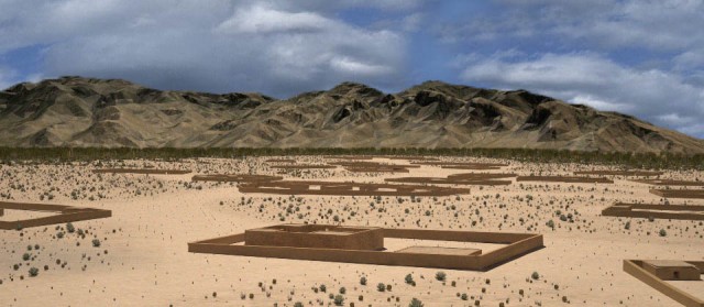
In addition to advances in digital graphics, we now have much more information to share with the public. Astonishing new data from excavations at the site of Las Capas have shown us what ancient farms actually looked like, as well as the unexpected scale and scope of Early Agricultural period settlements and farming systems. Excavations at Honey Bee Village and Marana Mound have refined our understanding of the forms and layouts of Preclassic (A.D. 500–1150) and Classic Era (A.D. 1150–1450) Hohokam villages. Moving just a bit up the timeline, recent excavations at the Mission Gardens and along edges of the San Agustín Mission have helped us better understand the village of Chuk-Son, the O’odham community established at the base of Sentinel Peak (popularly known as “A Mountain”) well before Hugo Oconór founded the presidio about three-quarters of a mile away in 1775.

At 11:00 a.m. on Friday, I heard the ping!, and my heart raced. Deep breath. Click.
We had a nice steak at our house that night.
With the generous support from the Southwestern Foundation, Archaeology Southwest is now in a position to create a digital visualization of the Tucson Basin through 4,000 years of human experience. Our deep digital library of 3D models includes fortifications, missions, pit houses, and platform mounds, as well as models of Sonoran Desert plants and specific local landforms. These assets will be essential to this revised and expanded visualization.
In 2014, 3D software developer Autodesk, Inc., recognized Archaeology Southwest’s innovative use of computer graphics for public interpretation of archaeological data with a donation of two complete sets of 3D development software packages. The grant award from the Southwestern Foundation enables us to take full advantage of Autodesk’s gift, through the acquisition of a specialized computing system for the creation, management, and rendering of digital assets. Because most personal computers sold “off the shelf” today are designed for the consumption of 3D digital media, we are going to build a new system designed for the production of 3D content.
The updated and expanded video project will incorporate new tools and rapidly evolving techniques for recreating ancient environments, using fresh data that have completely transformed our understanding of the Tucson Basin’s early villages and farms. The video will still begin in modern Tucson, but in this version, the viewer’s perspective will leave downtown Tucson to travel to the Pima County Wastewater Treatment Facility at Interstate 10 and Ina Road. The sewage treatment plant will fade away to reveal the site of Las Capas and the irrigation-based farms of the Early Agricultural period. The animation will then take viewers up the Santa Cruz River, revealing similar settlements at Flowing Wells and the site of Clearwater, with the associated trincheras settlement on Tumamoc Hill.
From there, the viewer will tour the reconstructed Hohokam village beneath downtown Tucson. The next segment will focus on a very different way of living at Chuk-Son and Bac (including the second church at San Xavier), followed by the construction of the current mission, and then the near-simultaneous constructions of the San Agustín Mission and the Tucson Presidio. The video will tie the experiences together by returning to modern Tucson.
Just as the previous video utilized local landmarks to keep viewers grounded within a space they understand and recognize, the updated effort will capitalize upon this simple idea to share deep history in a way that is visually intuitive and immediate. Tucson: Ancient, Historic, and Modern is currently used in schools ranging from elementary education to beginning courses in archaeology at the various universities, and an improved and updated version will continue to be an important and free resource for public education. By adding professional narration for English and Spanish versions, the educational and interpretive value of such a production situates it as a significant curriculum resource for meeting Arizona’s standards for fourth-grade education. Assets developed for the video project will also populate a touch-screen exhibit suitable for display in libraries and other public spaces.
With this award, Archaeology Southwest will be able to create a cohesive and innovative resource for sharing the story of 4,000 years of people’s lives in the Sonoran Desert. The Southwestern Foundation has been an important supporter of Archaeology Southwest’s work for many years. This most recent grant will be the thirteenth we have received from the foundation since our first in 1998. For myself and everyone at Archaeology Southwest, I’d like to express our appreciation for their ongoing confidence in our work.
3 thoughts on “Tucson: Ancient, Historic, and Modern”
Comments are closed.
Explore the News
-
Join Today
Keep up with the latest discoveries in southwestern archaeology. Join today, and receive Archaeology Southwest Magazine, among other member benefits.
Cangratulations to you, Doug, and to Archaeology Southwest!
And thanks to Dianne and the Southwestern Foundation!
Sounds great. Hope to see it as it.progresses. Congratulations! Kits