- Home
- >
- Preservation Archaeology Blog
- >
- An Adobe Pompeii

(January 21, 2016)—When reading book reviews or other arguments in archaeology, one of the more common put-downs is the dreaded “Pompeii premise.” An archaeologist accused of this, so it goes, has been naive in assuming that the objects found in a given place reflect the actual last use of that place—as actually did happen at Pompeii, where people, their settings, and all of their objects were all recorded as a moment in time, in a tragic cloud of burning volcanic ash.
Although nowhere near as dramatic as preservation by volcanic eruption, SWCA Environmental Consultants’ recent exposure of an incredibly rare record of people farming along the Santa Cruz River 2,500 to 3,000 years ago has the Tucson archaeological community abuzz. The record was made in muddy sand and clay, on what had to have been a “wet day on the farm.” Looking at the various tracks of prints, it is easy to imagine the ancient farmers running into their fields to open and close the irrigation canals that watered their fields of maize.

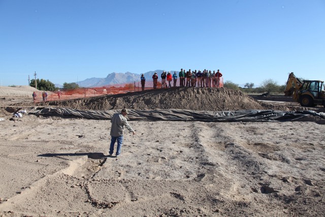
Archaeologists from SWCA (Suzanne Griset, Principal Investigator) and Pima County observed the footprints of women, men, kids, and dogs, as well as three-dimensional remains of irrigation canals, field boundaries—even planting pits. All marked in a single muddy surface that dried out and hardened into solid adobe, which was then, some days later, buried in a flash flood so intense the entire area was blanketed in clean sand before the previously dried mud record could melt.
We were alerted to the find on December 7, 2015. I grabbed my digital photogrammetry toolkit and rushed out to the site with fellow preservation archaeologist Allen Denoyer, who is an expert on the excavation of Early Agricultural period deposits.
What we encountered took our breath away.
The first exposure showed the boundaries of an irrigation canal and 20 to 30 footprints. SWCA graciously allowed me to record the deposit with three-dimensional photogrammetry.
From archaeological exposure to high-resolution 3D model in eight hours.
The deposit presented some immediate problems: here was a rare, and possibly unique, recording of at most two to three days in time some 3,000 years ago, in the path of a critical transportation project that could not be delayed or diverted. Discussions began immediately as to what would be the best way to record this amazing, but ultimately doomed, ancient surface.
First, SWCA archaeologists began to trace the surface further back in order to confirm that the footprint tracks continued outside the area of excavation. Even though we will eventually lose this part of the surface to bridge construction, we know that we have a much larger exposure that we may be able to use to share the “real thing” in a future public interpretation.
Then we joined with Arizona State Museum conservator Nancy Odegaard to discuss possible ways to save individual footprints and document the entire deposit, which by this time had expanded to roughly 300 square meters (just over 3,000 square feet). SWCA brought in a specialist in latex and epoxy mold casting to try and preserve specific prints, and Archaeology Southwest was hired to continue to record the expanding exposure of the ancient surface.
Over the next month, I had the opportunity to pull out all of the stops and explore what digital archaeology could offer to digitally preserve and interpret this ancient place. I took an aerial approach, using a camera on a pole to capture the entire exposure at millimeter-level accuracy, and then selected specific examples of well-preserved footprints to conduct higher-resolution modeling.
The Alpha Test Zone
With this model of the ancient surface created, we are now going on to experiment with how we may be able to share this digital model with the public. As it happens, Archaeology Southwest has developed a pretty nifty tool to build virtual exhibits, called “Chronological Virtual Reality.” We imported the digital models into our CVR system and quickly built an online tool to share the footprints of Sunset Mesa.
This web interactive model is still in Alpha testing, but if you would like to try it, please feel free. Just beware that it might take a bit of time to download:
Sunset Mesa Footprints – Web-based Virtual Reality
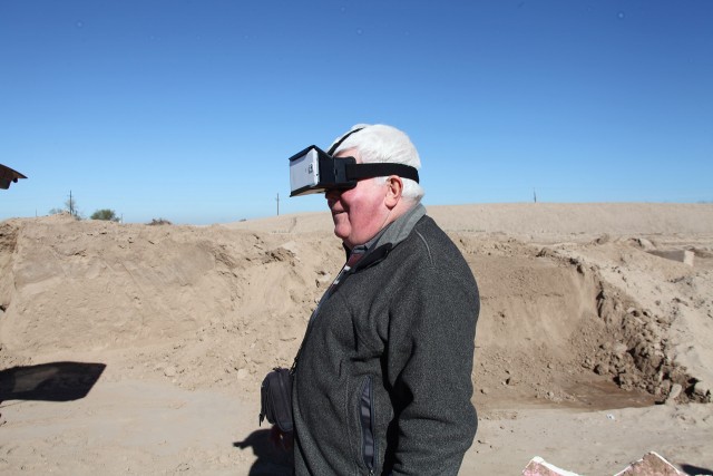
Finally, we used the CVR system to build an application that utilizes Google’s ingenious Cardboard system for smartphone-based virtual reality.
The Sunset Mesa App for Google Cardboard is also still in Alpha testing, but if you are interested enough to set your Android Phone to developer mode, you may download and install the “.apx” file to experience the Sunset Mesa Apps in true virtual reality. If you are not sure how to install an apx app, the program will be available for free on the Google Play and Apple App stores soon.

Sunset Mesa Cardboard Demo (apk format)
Right-click or Control-click to save link as a file.
We are just getting started. More portions of the site will be exposed soon, and we will continue to update this project as new footprints and more portions of this ancient place again see the light of day.
Explore the News
Related to This
-
Project Tucson Origins