Imaging the Past: Places of Meaning, Moments of Wonder
Archaeology Southwest Magazine Vol. 25, No. 3
Free PDF Download

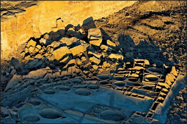
Threatening Rock and Pueblo Bonito at Chaco Canyon, by Adriel Heisey
This issue’s authors seek to understand and convey past, place, human life, and the complex relationships among these through images from above, beneath, and beyond. Some of these images have been created through the authors’ own work, and some were created in the early days of aerial photography. Some are virtual, some are actual; some are resonant, some are static; all are, in some way, being preserved against the disintegrations we can predict.
Places of Meaning, Moments of Wonder — Adriel Heisey
Visit Adriel Heisey’s website.
Explore From Above: Images of a Storied Land online.
Find the exhibition’s companion volume at Archaeology Southwest’s bookstore.
Learn more about Heisey’s most recent book, The Rio Grande: An Eagle’s View.
Imaging with Ground-penetrating Radar — Lawrence B. Conyers, University of Denver
Ground-penetrating Radar and Buried Canals: The Rillito Fan Site
Explore Dr. Conyers’s research and recent publications at his web page.
Oblique Views: Time and Change in Southwestern Landscapes — Linda J. Pierce, Archaeology Southwest (formerly Center for Desert Archaeology)
Learn more about the Oblique Views project.
Visit the websites of the Palace of the Governors and the Museum of Indian Arts and Culture.
Experience Third Views, a seminal rephotography project that inspired the Oblique Views team.
Recommended reading:
Berg, Erik
2004 “The Eagle and the Anasazi: The Lindberghs’ 1929 Aerial Survey of Prehistoric Sites in Arizona and New Mexico.” The Journal of Arizona History 45(1): 1–30.
Three Views of Chaco Canyon’s Pueblo del Arroyo — R. Gwinn Vivian, Arizona State Museum (Retired)
Learn more about Chaco Culture National Historical Park.
Watch Dr. Vivian’s Tea and Archaeology presentation on life in Chaco Canyon.
Saving the Lindbergh Negatives
Find out more about the conservation of nitrate negatives by the Arizona State Museum and in a bulletin by the National Park Service.
The 1930 Aerial Survey of Prehistoric and Historic Canals in the Salt-Gila River Region — Todd W. Bostwick, Verde Valley Archaeology Center and PaleoWest Archaeology
Correction: The aerial mosaic photograph on page 7 is incorrectly captioned. The image is of Florence, not Tempe and Mesa. We sincerely regret the error.
Examine the survey path map.
Aerial mosaics of Mesa and Tempe may be viewed here.
Visit the websites of the Smithsonian’s National Anthropological Archives (NAA) and Pueblo Grande Museum.
Read more about the collection at the NAA’s website.
View an online catalog of images from this survey by entering the the keywords “aerial photographs Hohokam canals” in the search window here.
Modeling the San Agustín Mission — Douglas W. Gann, Archaeology Southwest (formerly Center for Desert Archaeology)
View the most recent version of the Mission San Agustín model. The model is presented in Google Earth.
The American Southwest Virtual Museum — Christian E. Downum, Meghann M. Vance, and April D. Peters, Northern Arizona University
Explore the American Southwest Virtual Museum.
Digital Re-creations of Ancient Life — Christian E. Downum, Northern Arizona University, and Victor O. Leshyk
Visit scientific illustrator Victor Leshyk’s website.
Stabilization of Three Corn — Larry Baker, Salmon Ruins Museum, and William H. Doelle, Archaeology Southwest (formerly Center for Desert Archaeology)
View the slideshow of Three Corn’s stabilization.
Watch Dr. Ron Towner’s Archaeology Café presentation on pueblito architecture in the Dinétah.
Back Sight — William H. Doelle, Archaeology Southwest (formerly Center for Desert Archaeology)
Experience a preview of Virtual Southwest. The preview is presented in Unity 3-D.
Find out more about Archaeology Southwest’s partnership with Salmon Ruins and Preservation Archaeologist Paul Reed’s research.
Read a free PDF of Archaeology Southwest Magazine Vol. 16, No. 2, “Salmon Ruins: Past, Present, and Future.”
Subscribe

